National Coastal Erosion Study (NCES)
Department of Irrigation and Drainage Malaysia
National Coastal Erosion Study (NCES)
based on NCES 2015
National Coastal Erosion Study (NCES)
Maps gallery - Coastal Erosion Location, Coastal Zone Information, Erosion Control Measures, Coastal Process & Shoreline Condition

National Coastal Erosion Study (NCES)
About NCES
Introduction
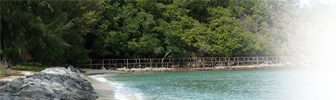
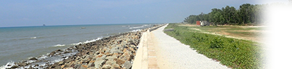
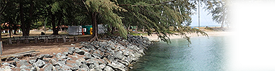
Malaysia has about 4,800 km of coastline. Almost all the coast comprises of easily eroded alluvium. Sands are the most common coastal soils in Sarawak and along the eastern coast of Peninsular Malaysia. Clays and silt are the most common soils along the western coast of Peninsular Malaysia. The two types are about equally common along the coast of Sabah. Mangrove forests, generally associated with the clay and silt areas, front about half of the coast forming a natural protection against waves. The mangrove-vegetated areas are now decreasing due to wave action, natural phenomena and human activities.Erosion along the coastline is widespread. Consequently coastal erosion is a national rather than a local problem in Malaysia. There are many important economic and social activities taking place in the coastal areas, the consequences of coastal erosion have increasingly become a serious concern.
The earlier NCES was done under the auspices of the Economic Planning Unit (EPU), Minister Department in 1985 to identify erosion area and effect of erosion to economic and social activities. The study covered the coastline for Peninsular Malaysia (includes Pulau Tioman, Pulau Langkawi and Pulau Pinang), Sabah (include Pulau Labuan) and Sarawak. It generally excluded most of the coastline along Johor Straits.
The study classified eroding coastal areas according to the immediacy and seriousness of the erosion threat to existing facilities. The basis of the study is identifying critical erosion areas with an aggregate length of 140 km where facilities that were in immediate danger. Significant erosion areas with an aggregate length of 240 km consisted of facilities that would be endangered within 5 to 10 years. Acceptable erosion areas with an aggregate length of more than 900 km are generally undeveloped and presently contain no facilities that will be endangered within the foreseeable feature.
Coastal Zone
It is the interface between land and sea, delineated as part of land affected by its proximity to the sea and part of the sea affected by its proximity to the land. The coastal zone is broadly defined as the area where terrestrial and marine processes interact. These include the coastal plains, deltaic areas, coastal wetlands, estuaries and lagoons.
The term coastal zone is defined as a narrow area of land and wetland immediately adjacent to the shoreline; a line where the sea and the land intersect. The coastal area can be classified into landscape units i.e. backshore, foreshore, nearshore, offshore, beach and berm.
For the purpose of preparing the Integrated Shoreline Management Plan (ISMP), the datum used is based on the definition given by the United Kingdom Hydrographic Office (UKMO, 2005)
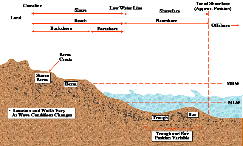
Classification of the coastal zone
Source: USACE, 2002
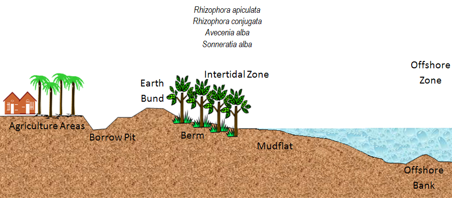
Typical profile of muddy coastal zone in Malaysia
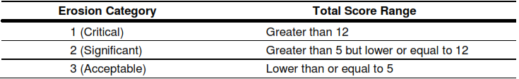
Erosion Categorisation
An erosion severity categorisation system has been proposed and applied in this Study to categorise the stretches of coastline that are eroding. In broad terms, the categorization system is based on two parameters, namely physical coastline retreat rates and economic significance of the coastline.
There are three categories of erosion severity on a 1 (Critical) to 3 (Acceptable) scale. In general, the erosion severity increases with the physical erosion rates and economic significance of the coastline at risk of erosion, as shown in Figure 1. As an example, a fast-eroding stretch of coastline with a high population density will be assigned as a “Category 1” erosion site. On the other hand, a slowing-eroding and sparsely populated stretch of coastline will be identified as a “Category 3” erosion site.
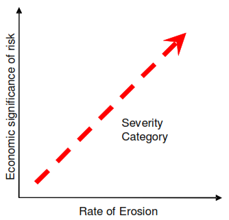
Figure 1: Erosion severity category increases with erosion rates and economic significance of the coastline at risk of eroding
The representative description of the state of coastline in each erosion category is as follows:
- Category 1 – Critical Erosion: Fast retreating coastline at the rate of more than 4 m/year with generally fairly dense human settlement, with some commercial/industrial activities being served by significant public infrastructure and facilities;
- Category 2 – Significant Erosion: Retreating coastline at the rate of between more than 1 m/year but less than 4 m/year with generally sparsely-populated area, with some agricultural activities being served by relatively minor public infrastructure and facilities; and
- Category 3 – Acceptable Erosion: Slowly retreating coastline of less than 1 m/year with generally no human settlement and minimal agricultural activities, and not served by public infrastructure and facilities.
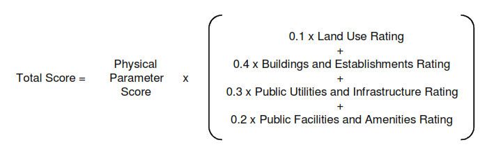
Physical Parameter
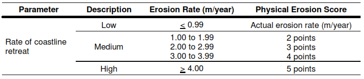
Physical erosion rates of coastline analysed from historical satellite images have been used as the physical parameters in determining the erosion categorisation. It is noted that the erosion rates may vary along a stretch of eroding coastline. The maximum retreat rate analysed has been used for the purpose of erosion categorisation.
The scoring for physical parameter based on the physical erosion rates are given in Table 1. Physical erosion is considered “High” for annual erosion rates greater than 4 m/year and “Low” for annual erosion rates less than 1 m/year. Erosion rates that ranged between 1 and 3.9 m/year are considered as “Medium”.
Economic Parameter
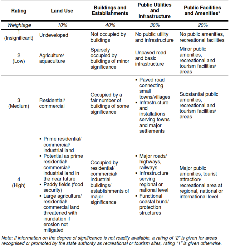
Economic parameter is based on the economic significance of the stretch of eroding coastline. It is considered that for the purpose of erosion categorisation, the economic significance can be described by the following components:
- Land use – The type of land use include undeveloped land, agriculture/aquaculture, residential/commercial, prime residential/commercial, industrial;
- Buildings and establishments – density of buildings and establishments and their significance to the community;
- Public utilities and infrastructure – type and significance of public utilities and infrastructure including roads and railways.
- Public facilities and amenities – type of public facilities and amenities that are of local, national or international significance.
The scoring for different economic parameters is given in Table 2. The weightage associated with each of the economic components is also included in the table.
Steps in Determining Erosion Category
The following steps are to be followed sequentially in determining the erosion category for each of the erosion sites:
- Step 1: Determine the physical parameter score associated with the maximum average annual erosion rate analysed from satellite images;
- Step 2: Determine the score associates with each of the components of the economic parameter based on their economic significance; and
- Step 3: Compute the Total Score as follows:
- Step 4: Categorise the eroded stretch of coastline by its Total Score to Category 1, 2 or 3 based on Table 3.
Special Considerations in Determining Erosion Category
There could be unique value dimensions that are not fully or adequately captured by the erosion categorisation system. These value dimensions are mostly uncommon and occur only in special circumstances that are not appropriate to be applied to nationwide sites. Examples of these value dimensions include national landmarks, heritage sites and environmentally sensitive areas. Where such circumstances exist, special considerations can be used to adjust the erosion category.